A History of the
Geography of New York City (revised version)
By Stephen P.
Morse & Joel D. Weintraub
An early version
of this article appeared in Dorot Volume 36-1, Fall
2014
A copy of that
version, augmented with additional material, appears here.
This revised
version was written in August 2019
Introduction: New York City
has undergone numerous changes in its geographical boundaries. An understanding of these boundaries is
important in order to know which archive to search in when looking for vital
records. This paper discusses the
changes to New York City's geography over the years, and describes the difference
between New York City and the City of New York.
Present Day New York: Let's start by
looking at the present geography of New York.
New York City and the City of New York are now synonymous terms and
consist of the five boroughs, namely Manhattan (New York County), Brooklyn
(Kings County), Queens, the Bronx, and Staten Island (Richmond County). Note that each borough is a county but
possibly with a different name. This was
not always the case. Note that
everywhere else in the country, a county contains one or more cities. In New York, there are five counties within
one city.
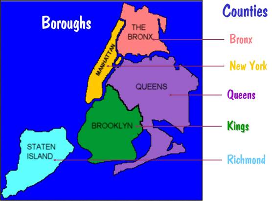
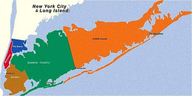
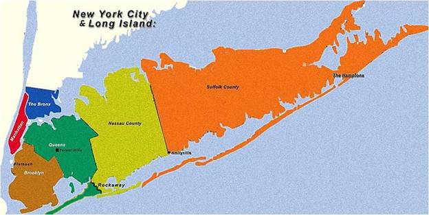
The five boroughs and
counties of New York City
The
Boroughs of Manhattan (less the Marble Hill section discussed later) and Staten
Island are on their own islands, while Brooklyn and Queens are part of a larger
island known as Long Island. By common
usage, the term "Long Island" refers to the parts of the island that
are outside the city boundaries -- namely Nassau County and Suffolk
County. But this is a misnomer since
Nassau and Suffolk by themselves do not constitute an island. The Bronx is not an island but is connected
to the North American mainland and abuts Westchester County.
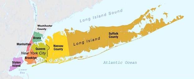
The major islands of New York City
As
we will see, New York City originally referred to Manhattan Island only. And to this day, common usage of the term
"The City" refers to just Manhattan, although that too is a
misnomer. Many maps with the title of
“New York City” turn out to be primarily maps of Manhattan.
The French, the Dutch, and the British: Here are the dates of some key events in the
early history of New York City.
|
1524 |
Giovanni
da Verrazzano, sailing for
France, discovers New York Harbor. He
names it New Angoulême. |
|
1609 |
Henry
Hudson, sailing for Holland, rediscovers New York Harbor and is given the
credit for its discovery. He continues
sailing up to Albany. |
|
1624 |
First
European settlers arrive in the region and name it New Amsterdam. |
|
1626 |
Governor
Peter Minuit purchases Manhattan Island from the Indians for $24 worth of
trinkets, or so it is alleged. |
|
1653 |
First
city charter is granted. |
|
1664 |
Governor
Peter Stuyvesant surrenders to the British Duke of York. New Amsterdam is renamed to New York. |
|
1673 |
Cornelis Evertsen recaptures New York for the Dutch and renames it
New Orange. But the Dutch didn't want it
back, and he is forced to return it the following year (oops). |
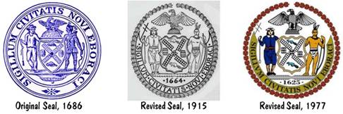
Some
of these dates are reflected in the city's seal. The original seal of 1686 didn't have a
date. The revised seal of 1915 gives the
date of 1664, which is the year that the city was first called New York. But there was some concern amongst New
Yorkers that Boston was claiming an earlier date of 1630. So in 1977 the City Council revised the seal
to display the date of 1625. Unfortunately
1625 doesn't have great significance in the history of the city. But it's close enough to 1624, which is the
year that the city received the name of New Amsterdam.
What is New York City's birthdate: As we've already seen from the seal, New
York doesn't seem to know when it was born.
Here are different answers that the city has given at different times.
|
|
City
seal shows 1625, a date that is close to 1624, the year that the city became
New Amsterdam. |
|
|
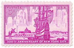
A
1953 postage stamp proclaims the 300th anniversary. That would imply a date of 1653, the year
that New Amsterdam was incorporated by the Dutch government and the first
city charter was granted. |
|
|
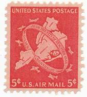
A
1948 postage stamp, commemorating the
50th (golden) anniversary for the City of New York, gives the date of
1898. That is correct if a distinction
is made between "New York City" and "the City of New
York." This will be discussed
later. |
How do you spell Verrazzano: As already noted, Giovanni da Verrazzano was the original
discoverer of New York Harbor, although Henry Hudson received the credit for
it. In 1964 a major bridge was built
connecting Brooklyn to Staten Island, and the City Fathers decided to give Verrazzano his long-overdue credit by naming the bridge
after him. Unfortunately, they
misspelled his name as Verrazano when the bridge was dedicated, blaming it on a
typo. That wasn't rectified until 2018
when Governor Cuomo signed a bill to correct the error and create new signage. The Jamestown Verrazzano
Bridge in Rhode Island had the correct spelling from the start.
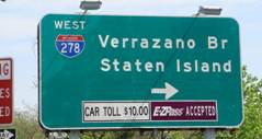
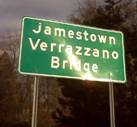
Verrazzano is misspelled
The Origin of the Counties: In 1683 New
York State was divided into 12 counties.
Of those, the ones that are today part of New York City are Richmond County (Staten
Island), New York County
(Manhattan), Kings County (Brooklyn), and Queens County. The land area of what is the Bronx today was part
of Westchester County. Queens County
then included what is today Nassau County.
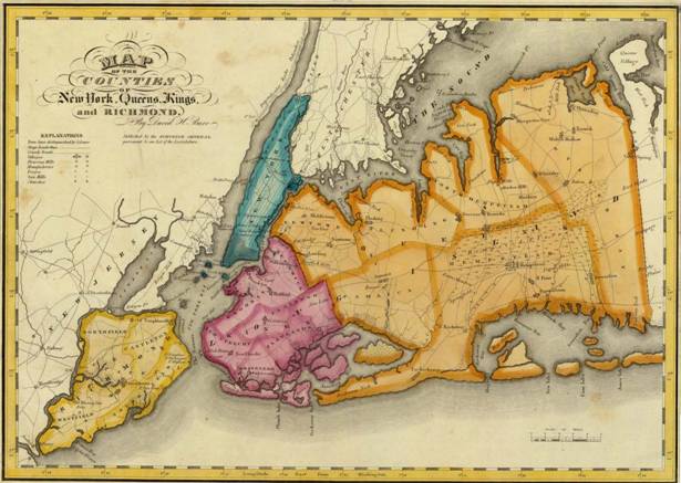
An 1829 map showing the counties of Richmond, New
York, Kings, and Queens
reprinted
from https://www.mapsofthepast.com/new-york-queens-kings-richmond-county-rawdon-1829.html
The
area of New York County (and, synonymously, New York City) remained static
until 1874. In that year New York County
expanded as the land west of the Bronx River (Kingsbridge, West Farms and Morrisania) was annexed from Westchester County. This is the western part of what is today the
Bronx. If you were looking for a person
in the New York State Census of 1875, and they lived in the western part of the
Bronx, you would find them on New York County census forms.
In
1895 the remainder of what is now the Bronx was annexed from Westchester
County. And in 1915 the Bronx was
removed from New York County and made into a county of its own.
So
now let's see what happens if you are looking for a New York State census
record of someone from the Bronx. For
censuses prior to 1874, you would look in Westchester County. For years between 1874 and 1894, you would
look either in New York County or Westchester County, depending on which side
of the Bronx the person resided. After
1894 and before 1915, you would look in New York County. And starting from 1915 you would look in
Bronx County.
And
in 1890, New York City took a so-called "Police Census" of the
residents of New York County. So a
person living in the West Bronx would be in that census but a person living in
the East Bronx would not be.

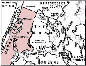
New York County 1683 to 1874 New York County 1874 to 1895
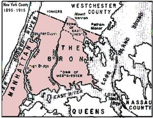
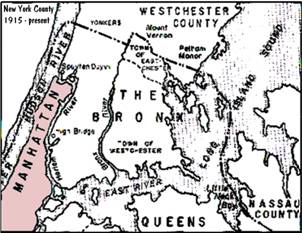
New York County 1895 to 1915 New York County 1915
to the present
And
county changes were occurring in the eastern part of the city as well. In 1899 the eastern portion of Queens County
broke away and formed Nassau County.
Queens County before 1899
Queens County from 1899 onwards
The Changing Geography of Brooklyn: The area that is
today Kings County began as six towns back in the 1600s. These towns and
the year in which each was founded are:
|
1645 |
Town
of Gravesend |
|
1646 |
Town
of Brooklyn (originally Breuckelen) |
|
1647 |
Town
of Flatlands (originally New Amersfoort) |
|
1652 |
Town
of Flatbush, western part (originally Midwout) |
|
1657 |
Town
of New Utrecht |
|
1661 |
Town
of Bushwick (originally Boswijck) |
|
1677 |
Town
of Flatbush, eastern part (originally New Lotts of Midwout) |
And
in 1683 Kings County was created and it consisted of these six towns. The changing geography of Kings County then
continues as follows:
|
1816 |
Village
of Brooklyn is incorporated |
|
|
1827 |
Village
of Williamsburgh (with an "h") is
incorporated |
|
|
1834 |
Village
of Brooklyn + Town of Brooklyn => City of Brooklyn |
|
|
1840 |
Village
of Williamsburgh => Town of Williamsburgh |
|
|
1851 |
Town
of Williamsburgh => City of Williamsburgh |
|
|
1852 |
Eastern
Flatbush => Town of New Lots |
|
|
1854 |
City
of Brooklyn annexes City of Williamsburg (dropping the h) and Town of Bushwick |
|
|
1886 |
City
of Brooklyn annexes Town of New Lots |
|
|
1894 |
City
of Brooklyn annexes Towns of Flatbush, Gravesend, and New Utrecht |
|
|
1896 |
City
of Brooklyn annexes Town of Flatlands |
|
The
unification of Brooklyn is now complete but it will be short lived.
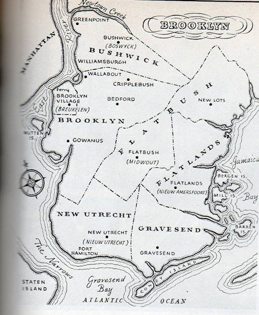
The original six towns of Brooklyn
For
comparison purposes, the following map shows the boundaries of the original six
towns overlaid on a contemporary neighborhood map of Brooklyn. The boundaries of the six towns are approximate. And there is no standard for the contemporary
neighborhood names or their boundaries.
So this comparative map should be taken with a grain of salt.
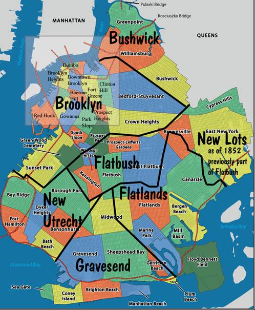
The original six towns overlaid on a contemporary
map of Brooklyn.
Contemporary map derived from the image at http://i.imgur.com/NqufQJT.gif
The Changing Geography of Queens: The area that is
today Queens County began as five towns back in the 1600s. These towns
and the year in which each was founded are:
|
1644 |
Town
of Hempstead |
|
1645 |
Town
of Flushing (orig. Vlishing) |
|
1652 |
Town
of Newton (orig. Middelburgh) |
|
1656 |
Town
of Jamaica |
|
1667 |
Town
of Oyster Bay |
And
in 1683 Queens County was created and it consisted of these five towns. The changing geography of Queens County then
continues as follows:
|
1784 |
Town
of North Hempstead splits off from Hempstead |
|
1870 |
Town
of Long Island City splits off from Newton |
|
1896 |
Newton
changes its name to Elmhurst |
|
1898 |
Borough
of Queens created, western part of county only |
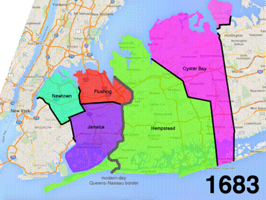
1683: Queens County created, consists of five towns.
This image and next four images reprinted from
https://ny.curbed.com/2015/10/20/9912148/how-queens-became-new-york-citys-largest-borough
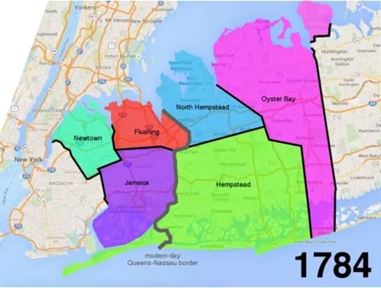
1784: Town of North Hempstead splits off from Town
of Hempstead.
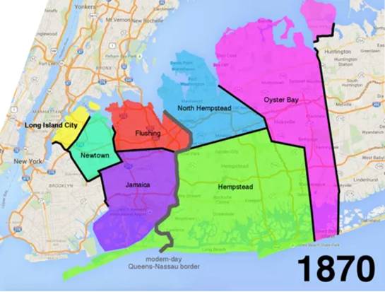
1870: Town of Long Island City splits off from Town
of Newton
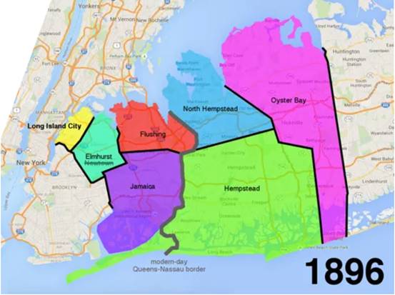
1896: Town of Newton changes its name to Elmhurst

Borough of Queens created, western half of county
only.
The Changing Geography
of The Bronx: We already learned part of this story when we looked at the
origin of the counties. In particular,
we saw that:
from 1683 (when the counties were formed) to 1874, Bronx was totally
contained in Westchester County
in 1874 New York County annexed the West Bronx from Westchester County
in 1895 it annexed the East Bronx too.
Let's look at this in a bit more detail.
Prior to 1846 the southern part of Westchester County
consisted of four towns -- namely Yonkers, Eastchester, Pelham, and
Westchester.
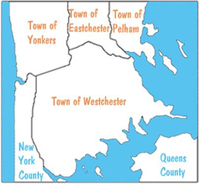
Southern Westchester prior to 1846.
In 1846 the town of West Farms is split off from the
southwestern part of the town of Westchester.
Then in 1855 the town of Morrisania is split off from the southern part
of the town of West Farms. And in 1873
the town of Kingsbridge is split off from the southern part of the town of Yonkers.
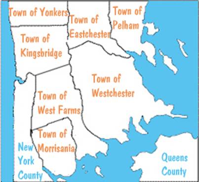
Towns of West Farms, Morrisania, and Westchester in 1873
Then, as already mentioned, the West Bronx was annexed by New
York County in 1874, and that consisted of the three towns we just mentioned
(West Farms, Morrisania, Kingsbridge).
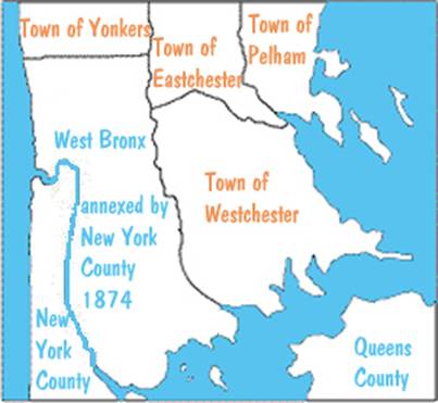
Annexation of West Bronx in 1874
The annexation of the East Bronx by New York County in 1895
involved carving some of the existing towns in Westchester County. Specifically the southern parts of the towns
of Eastchester and of Pelham were carved out, and they along with the town of
Westchester were all annexed by New York County. The reason for this carving had to do with a
referendum that had just taken place in 1894.
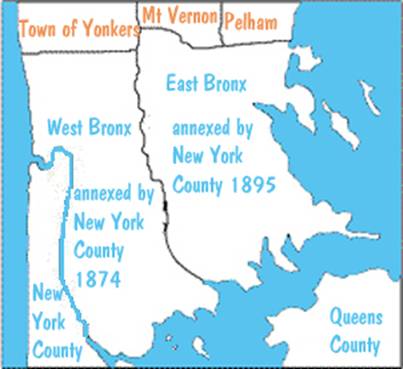
Annexation of East Bronx in 1895
The Changing Geography
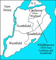
of The Staten Island: Prior to 1860, Staten Island
consisted of the towns of Castleton, Northfield, Southfield, and
Westfield. In 1860 parts of Castleton
and Southfield were carved out to form the town of Middletown. In 1866 the north shore of Castleton was
incorporated into the Village of New Brighton, and in 1872 the boundaries of New
Brighton were extended to make it coterminus with Castleton.
|
|
Original towns of
Staten Island
|
The Referendum: Discussions about
consolidating New York City with its surrounding areas started in earnest in
the late 1860s. A non-binding referendum
was put before the voters in 1894. Many
were opposed to the idea. The 1893 cartoon
from Puck Magazine illustrates this point. Mr. New York City is offering a marriage
proposal to Miss Brooklyn who seems interested, but the Brooklyn politicians
and newspaper editors are very much against it.
In the end, Brooklyn supported consolidation but only by 277 votes out
of 129,211 votes cast.
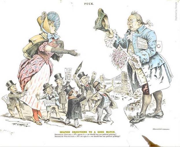
Puck Magazine, January 18, 1893
There
were several factors affecting the outcome in Brooklyn. As of the 1890 census, Brooklyn was the
fourth largest city in the United States, behind New York City, Chicago, and
Philadelphia. By the time of the
referendum in 1894, the City of Brooklyn had annexed almost all of Kings County
with the exception of Flatlands, which would be annexed in the following year. That would make Brooklyn the third largest
city. Brooklynites
didn't want to give up that distinction.
But on the other hand, Brooklyn was heavily in debt and bankruptcy was
looming. And Brooklyn had limited access
to water of any quality.
In
Westchester County the referendum was defeated in the town of Westchester (by
one vote) and the Cities of Mount Vernon and Yonkers. Flushing in Queens County voted no, while the
rest of what is Queens County today voted yes.
New York County (then Manhattan and West Bronx) voted yes, as did
Richmond County and the towns of Pelham and Eastchester, and the village of
Wakefield in Westchester County.
Given
the general agreement to go forward with the merger, New York County in 1895
annexed the eastern part of the Bronx from Westchester County, which included
the village of Wakefield, and the towns of Westchester, Eastchester, and part
of Pelham. Thus New York County and
therefore New York City then encompassed Manhattan and all of what is today the
Bronx.
The Consolidation: In 1897 New
York State Governor Black signed the charter of the City of New York (its official name) which would consist of the
counties of Richmond, Kings (Brooklyn), New York (including the Bronx), and the
western part of Queens County (what is today all of Queens County). The eastern Queens towns of Hempstead, North
Hempstead and Oyster Bay were excluded. The
new City of New York started on January 1, 1898. The air mail stamp, issued in 1948,
commemorated the Golden Anniversary of the City of New York.
Here come the Boroughs: Along with the
consolidation, the five boroughs were
established. They were (and still are)
the Boroughs of the Bronx, Manhattan, Richmond, Brooklyn, and Queens. Boroughs are a unique part of the city. Each elects its own President although their
political powers are limited. The
political power is in the hands of the mayor of New York City and the City
Council.
So
the term "City of New York" came into being in 1898 and consisted of
the five boroughs. At that point the
term "New York City," which previously referred to New York County,
should have ceased to exist. But "New
York City" continued to be used with some ambiguous meanings through the
years. Today the two terms are
synonymous.
Although
the city consisted of the five boroughs, it comprised only four counties. Bronx was not yet a county, and the Borough
of the Bronx was part of New York County.
Another peculiarity was that the Borough of Queens was not coterminous
with Queens County, instead it was only the western part of the county. The eastern part of Queens County was not in
the Borough of Queens and not part of the
new city. And the Borough of Richmond
posed yet another problem. Although the
official name was the Borough of Richmond, New Yorkers referred to it as the
Borough of Staten Island. These three
issues were cleared up by the following events.
|
1899 |
Excluded
areas of eastern Queens County seceded and formed Nassau County |
|
1915 |
Bronx
County is formed, resulting in five counties coterminous with the five
boroughs |
|
1977 |
Borough
of Richmond is renamed to the Borough of Staten Island |
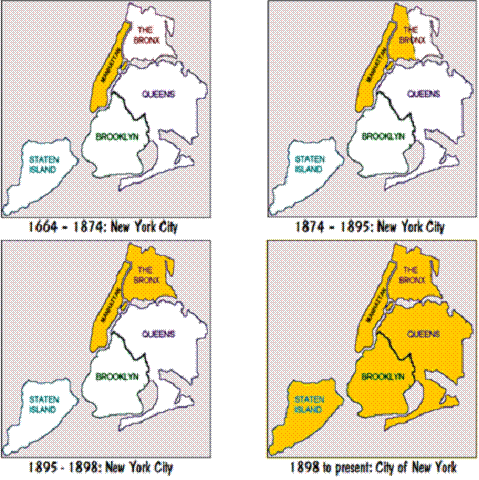
What is New York City: New York City was different things at
different times.
|
From
1664 to 1874 |
Only
Manhattan Island (New York County) |
|
From
1874 to 1895 |
Manhattan
Island and West Bronx (New York County) |
|
From
1895 to 1898 |
Manhattan
Island and entire Bronx (New York County) |
|
From
1898 to 1899 |
Five
boroughs and 3+ counties (New
York, Richmond, Kings, and western Queens Counties) |
|
From
1899 to 1915 |
Five
boroughs and 4 counties (New
York, Richmond, Kings, and Queens Counties) |
|
From
1915 to present |
Five
boroughs and 5 counties (New
York, Richmond, Kings, Queens, and Bronx Counties) |
The Marble Hill Anomaly: Marble Hill, with a Bronx zip code of 10463,
is the exception that proves the rule about historical knowledge leading to
correct genealogical resources. This
original northeast tip of Manhattan Island was once separated from the mainland
of the Bronx, to its north, by Spuyten Duyvil Creek. The Harlem Ship Canal was completed in 1895,
and it created a waterway on the south side of Marble Hill. This left Marble Hill surrounded by water: the
canal on the south and the original northern loop of the creek along the
remaining edges.
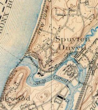
Marble Hill as an Island
reprinted
from https://orionmagazine.org/place/spuyten-duyvil-creek-inwood-new-york/
In
1914 the creek was filled in so that Marble Hill became part of the mainland of
the Bronx and was no longer on Manhattan Island.
Marble
Hill, however, remained in Manhattan Borough and New York County. In 1939 Bronx Borough President Lyons tried to
annex Marble Hill. Lyons even went there
as a publicity stunt and raised the flag of the Borough of Bronx over it,
declaring that community as a part of Bronx Borough. Mayor La Guardia then recommended that Marble
Hill be placed in the Bronx but angry residents opposed the plan. Governor Lehman sided with the residents and
that ended the takeover attempt.
In
1983 a court ruled that Marble Hill was in Manhattan Borough and in Bronx
County! That paradox was quickly
addressed by the New York State legislature, which in 1984 put the area firmly
back within New York County and the Borough of Manhattan.
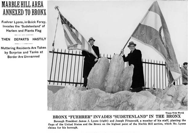
The attempted take-over of Marble Hill in 1939
Telephone Area Codes: In addition to counties and boroughs, area
codes also serve to geographically split up the city. Area codes were introduced nation-wide in
1947, and at that time New York City was assigned area code 212. The reason they chose 212 is because it is
the fastest area code that you could dial at that time using a rotary dial phone.
By
1984 they were running out of numbers in the 212 area, so they kicked Brooklyn,
Queens, and Staten Island out of 212 and put them into a newly created area
718. That of course created quite an uproar in
places like Brooklyn where the residents felt that they were being removed from
New York City whereas the residents of the Bronx were allowed to stay. But that inequity was rectified in 1992 when
Bronx (along with Marble Hill) was moved into 718. That left just Manhattan in 212.
From
1992 on, no new area codes were created, but overlays for 212 and 718 were
defined. Specifically in 1992 the overlay 917 was created to cover both 212
and 718, and in 1999 the overlays 646
and 347 were created to cover 212 and 718 respectively. In 2011 overlay 929 was created for 718, and
in 2017 overlay 332 was created for 212.
In case your keeping score, that makes two overlays specific to 212, two
specific to 718, and one that encompasses both 212 and 718.
Postal Zip Codes: The first three digits of zip codes are
yet another way to geographical split up the city. But they haven't changed much since they were
first introduced in 1963 and were made mandatory in 1967. Here are the zip code prefixes for New York
City:
100xx
Manhattan (in general)
101xx
Manhattan (certain large buildings)
102xx
Manhattan (certain large buildings)
103xx
Staten Island
104xx
Bronx
112xx
Brooklyn
110xx
Queens (Floral Park)
111xx
Queens (Long Island City)
113xx
Queens (Flushing)
114xx
Queens (Jamaica)
116xx
Queens (Far Rockaway)
In
addition to 101xx being used for certain large building in Manhattan, the
region on the upper east side from approximately East 86th Street to East 96th
Street has zip code 10128. That zip code
was carved out of zip code 10028 in 1983.
Similarly
102xx, in addition to being used for certain large buildings, is used for a
region around Battery Park -- namely zip code 10280.
While
we are on the topic of zip codes, a word about postal address is in order. Normally the last line of a postal address
contains the city and state, as for example San Francisco CA. But that is not the case in New York
City. Instead the borough name is used
in place of the city name and we have Brooklyn NY, Bronx NY, and Staten Island
NY. But there are two exceptions. In Manhattan the county name is used and we
have New York NY. And in Queens the
neighborhood name is used and we have things like Flushing NY, Jamaica NY,
etc. There are numerous neighborhoods in
Queens and their names and boundaries are not always well defined. So the Postal Service will let your use the
neighborhood name of your choice as long as you include a valid zip code.
The Street-Name Problem: One byproduct
of the consolidation of the areas into the City of New York was the loss of
autonomy of the small communities in Queens and Staten Island. Eventually those original communities grew
together, and that created a problem with street names and house numbering,
since a street could change its name every few blocks. Queens then underwent a massive street name
change and address renumbering process in the 1910s and 1920s, which makes it
difficult to locate old addresses on modern maps. Staten Island also changed many street names.
A
collection of resources for resolving problems with old street names has been
compiled and it appears at https://stevemorse.org/census/changes. That utility contains information about
street name changes for many cities of the United States, and certainly New
York City is included.
In
addition to street name changes, the utility shows the conversion of old house
numbers to the modern house numbers for streets in Queens.
Conclusion and Credits: Although the
history of New York City/City of New York is obviously unique to that area, it
illustrates that an understanding of the history of street names and address
number changes, the changing boundaries of communities, and what political
units they were in, are often crucial for deciding which archives or
collections have the information you seek. Location, Location, Location, isn’t only the
realtor’s motto; it is the motto of successful genealogists as well.
We
thank Gloria Weintraub for providing critical
comments on this paper.